 An official website of the United States government. Here's how you know.


The maps in the Blue Book section on American Operations in the Meuse-Argonne region give students an opportunity to think about the nature of fighting in World War I and the successes enjoyed by the American Expeditionary Force. How great was the United States’ contribution to the Meuse-Argonne offensive, and ultimately, the war? Why was this “turf” so significant?
Guiding Questions
- How can students use maps from the ABMC Blue Book to describe and evaluate the United States’ contribution to the Meuse-Argonne offensive and World War I?
- What do various maps reveal about the nature of fighting by American units in World War I and the importance of the contested territory?
Learning Outcomes
The student will be able to:
- Use maps from the Blue Book to explain why American involvement in the Meuse-Argonne region was critical to the outcome of the war.
- Describe the nature of fighting in the Meuse-Argonne region.
- Assess the perspective and purpose of mapmakers.
Pre-activities
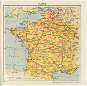
- Use the Reading Maps gallery to discuss the major geographic features of France based on the Blue Book map. Ask students to guess why certain areas are important. Emphasize the importance of the river, railroads, and progress of the war to that point. See the captions in the Gallery for more information.
Activities
- Put students in groups of 2-3 to study the Reading Maps handout. You might have them color or draw a line between Belgium, France, and Germany on the map to help them visualize the nations clearly. Ask them to consider:
- If you are a German commander, what would your next goal be? How would you explain your positions to the Kaiser?
- If you were an Allied Commander and were able to direct the newly arriving Americans, what region would you end them to? Why?
- Finally, does this map tell you everything you need to know as a commanding officer of the army? What else would you need to know, and where could you find it?
- Discuss possible answers below:
- Importance of gaining the high ground, getting closer to Paris, maintaining controls of rivers and railroads for supplies and transportation
- The area surrounding the Meuse River to prevent Germans from getting closer to Paris, aim for control of rivers, railroads, and high ground. See above answer.
- No! What is the strength of the opposing armies, where are they receiving supplies from, where have trenches been dug? See other military maps for help.
- In order to have students understand the importance of the region, they will need to closely study the geographic features of the area and the terrain gained by Allied soldiers. Page 191 illustrates ground gained in the war, and the map on 190 shows how German divisions moved to that area. Page 189 illustrates the Allied attacks in the same time period. Each of these maps gives different information about fighting in the Meuse-Argonne in early November. At this point, have students study the three maps on the handout and answer the quiz questions below:
- What appears to be the goal of American forces at this time? (to reach Sedan)
- Why would Sedan be an important point to reach? (Railroads and river)
- In what direction were Allied troops moving at this time? (East/Northeast)
- Did Germans move more troops toward the front line or away from it during the Meuse-Argonne Offensive (Toward)
- About how many miles of ground did the First Army gain between November 1 and November 11? (about 20)
- Was the town of Sedan ever re-captured by the Allies? (No)
- Did Allied forces ever cross the Meuse River? (Yes)
- What was the terrain like during the final 10 days of fighting? (Mostly fields and farms)
After students complete the quiz, ask them how they would describe fighting during the last 10 days of the war, based on the maps.
- Discuss:
- Why do they think American forces were able to cover so much ground during this time? (new troops brought energy and fervor against a tired enemy, gained the high ground quickly and had an advantage, much of the fighting was on open terrain).
- What does this indicate about the progress of the war once the Americans became involved? (The Americans helped bring the war to a close in a very quick manner).
- Using the gallery of maps as artifacts of World War I, discuss with your students the following:
- What does this image tell us that other images do not?
- What is this map used for? Who would find it most helpful?
- What else would you like to know if you were using this map?
- Each of these maps deals with terrain contested during the war. Ask students:
- What inferences can be made about the kind of fighting performed by Americans and their Allies?
- How similar or different were their experiences?
- What were the results of American involvement?
- Use the last image of the Maps as Artifacts Gallery to guide students through a newscast activity. Students may present their newscasts live to the class or record them for later submission. The main goal of this activity is for students to analyze why it was so critical for American forces to attack in the Meuse-Argonne region.
Assessment
Assess students based on their worksheets, class discussion, and the newscast activity.
Modifications
Teachers could eliminate the Battle Map Newscast and focus on the map-reading activities in order to shorten the lesson.
Materials Needed
Reading Maps Gallery
Reading Maps Handout
Maps as Artifacts Gallery